We are happy to introduce the HSIP Helper at www.HSIPhelper.com for agencies to explore systemic countermeasures for their California HSIP Cycle 7 applications. For more background information, please see our previous post.
The intent of the HSIP Helper is to illuminate the high benefits of systemic countermeasures and to help those agencies exploring their data to identify potential countermeasures that they may not have previously considered for their HSIP application. If your agency already has picked out their projects, this tool will not be beneficial.
Before we dig into any more details, it is important to note that this tool is not an official tool of the California Department of Transportation. It is provided independently by RoadSafe GIS and the results cannot be submitted with your HSIP application. You are still required to utilize the official application forms, when preparing your applications for HSIP. However, we have done our best to synchronize our HSIP Helper with the values and calculations used in the official tool to ensure your results are meaningful.
Ok, back to the tool. Here’s the basic example use case. You have generated a count of collisions for either the roadway, non-signalized intersection or signalized intersection category and are entering them for individual countermeasures in the application tool. However, what if you were also interested in looking at a few more potential countermeasures? You would have to click Select Countermeasure again and choose the new one to refresh the benefit values each time. It is not the most time consuming task, but if you wanted to compare side by side, you would have to write down the values, take a screenshot, copy the numbers into a spreadsheet or input again into the second or third countermeasure. Wouldn’t it be nice to just get a quick list of the different countermeasures so you could evaluate them further? That’s exactly what the HSIP Helper does:
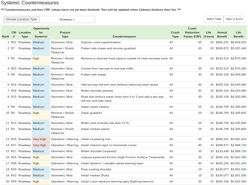
The list shows the countermeasures by location type (Signalized, Non-Signalized, or Roadway) and ranks by the benefit amount. All the countermeasures you may have been considering are shown and can be copied into a spreadsheet or directly opened in Excel. In Excel you could then add some project cost estimates to get a rough idea of the benefit/cost values.
As an added benefit, you may see other countermeasures you had not previously considered that could result in higher benefit/cost ratios. The ‘Opportunity for Systemic’ column is pulled directly from the Caltrans Local Roadway User manual and is color-coded to highlight the ‘high’ and ‘very high’ opportunities for systemic application. The ‘very high’ category means a countermeasure is typically easiest to implement at multiple locations and also one of the lowest costs. It is good to keep these categories in mind, because even if a countermeasure has a higher total benefit, it may be more expensive to implement, thus reducing the overall benefit/cost ratio.
Now, will all the collisions you selected for screening be valid for all of the countermeasures in the list? No, of course not. You likely pre-selected a set of collisions that were determined to be valid for a particular countermeasure, so other countermeasures might not be relevant. The HSIP Helper simply displays different possibilities for consideration. Therefore, engineering judgement is still critical to select countermeasures that are applicable for a given set of collisions.
Another benefit of the HSIP Helper is the ability to directly import more types of files than possible with the TIMS B/C tool. With HSIP Helper you can import:
- a .csv file downloaded from TIMS
- a .txt file from the CHP I-SWITRS
- Crossroads software files:
- zipped shapefile
- .txt
- .csv
- Google KML file
The import options allow you to quickly import different sets of collision data for analyses.
You can go to the ‘How it works’ help page for more information on using the HSIP Helper. Try it out and let us know what you think!
The HSIP Helper will become part of a suite of tools available in RoadSafe GIS to aid roadway safety management processes outlined in the Highway Safety Manual (HSM). RoadSafe GIS is a web-based service for collision data management and analysis. If you are looking for a new system for managing your collision data, check out the site and contact us at info@roadsafegis.com for a free demo account.